|
The morning started bad. Overnight my
mobile phone had decided to update some of the apps entirely on its
own. My email was one and no longer worked. I’m off on a bike pack
trip so the email was fairly important. To catch the 06:31 train to
the start meant I needed to leave home at 06:00 to get to the
station on time. I was reluctant to wake my son to help me out but
he managed to get the email working. I made the station on time but
was annoyed that the announcement said the train would be late. How
on earth can the first train of the day be late? Especially on a
Saturday morning with few workers & commuters around. When the train
arrived there were already a couple of bikes on board. I’d
previously bought a return to Edinbugh but only stayed on the train
till Carlisle. The Railway Station is still the original
architecture and is similar to Preston and very impressive. |
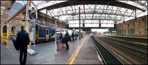
Carlisle Railway Station |
|
I arrived just after 8am and had to
wait till 09:26 for my next train. It left on time and took me the
short ride to Lazonby. It’s one of the delightful stations on the
Settle Carlisle line but like most small stations is unmanned. I
wheeled my bike down the path to the road & set off under cloudy
skies. |

Lazonby Railway Station |
|
On the outskirts of Kirkoswald I
turned right to Glassonby, Gamblesby and on to Melmerby. I stopped
briefly before setting off on the 5mile ride up the road pass to
Hartside summit. I’ve ridden it before on my road bike but not
weighted down on my touring bike. The road was engineered in the
1830s by John McAddam and is a constant gradient all the way to the
summit. I needn’t have worried as the climb was steady all the way
up and presented no problems. I managed the 5mile climb in about
50min. |

Hartside summit 580m (1,903ft) |
|
On the way I was passed by 3 cyclists
on road bikes. There were also a lot of motorcyclists. Approaching
the summit at 1903ft It became misty. At the top I photographed my
bike by the summit sign across from the Hartside Cafe then started
the wonderfully easy descent to Alston. My next obstacle was the
steep cobbled climb through the town. I cycled up as far as the
market building then decided to push the bike. My next call was
Nenthead where I knew there was another steep climb. I hadn’t ridden
far out of Nenthead before getting off to push. Half way up I
stopped to eat some biscuits when a cyclist coming down the other
way stopped for a brief chat. He was heading for Hexham which is a
delightful ride. |

Alston |
|
I part pushed and part cycled to the
Summit of Killhope Cross which is the highest ‘A’ road in England.
It is also where I entered Weardale and County Durham. Over the top
the first part of the descent is very steep and needed care. By
Cowshill the worst of the descents were over and I had a wonderful
flat road with the wind behind me. I reached the Weardale Museum and
High House Chapel. It was 1:35pm and the sign said it opened at 2pm
but also said ‘open’. The door was unlocked so I went it. There
wasn’t enough time to do a £3 visit justice so I’ll have to return
another time. |

Killhope Cross summit |
|
Further on I stopped briefly by the
Saint John’s Chapel Town Hall which now seems to be a community
centre. The easy ride continued through Daddry Shield to Stanhope
where there were many motorcyclists. At Wolsingham I left the main
road and turned left on to the B6296. Just when I’d got used to
riding on the flat the climbs started again. I had a couple of long
drags but they weren’t so steep that I needed to push. At the top I
turned right through minor lanes to Tow Law. |

Saint John’s Chapel |
|
I stopped to buy a couple of 2lt
bottles of water. I was nearing the end of my planned ride for the
day. Turning right I rode towards a collection of huge wind turbines
which looked surreal as I got close to them. On my right was a wall
so I looked for a campsite behind it and out of view from the road.
I found a suitable spot but it was too close to one of the noisy
turbines. |

View from the tent |
|
I returned to the road and continued
for another mile. On my left was a car park and sign for Hedleyhope
Fell nature reserve. I wheeled my bike through a couple of gates and
came to a spot with wonderful views of the surrounding countryside.
There were a few people about on the paths across the area so I
pitched my tent away from the path near a wooded area. |

Hedleyhope Fell camp |
|
|