|
The rain continued on and off through
the night. I delayed my start so as to get more light and hopefully
less rain. I didn’t get either. After packing a soggy tent away I
set off in full waterproofs heading east along the muddy lane to
Ashiestiel Bridge. Crossing over the River Tweed I joined the A707
for a short way then north along the B710. |
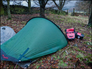
Wet camp above the River Tweed |
|
This follows Caddon Water up the
valley. The river was in flood and a dirty brown colour. At
Clovenfords I continued into Galashiels in pouring rain and very
dark and gloomy conditions. There was an Aldi shop so I stopped for
a look inside but didn’t see anything I fancied. I pressed on
through the town and on to the B6374. |

Rainy view from near the tent |
|
I noticed a stone plaque in the wall
on the left. Even though it was pouring down I though I’d better
check it out as I’d noticed ‘Sir Walter Scott’ in large lettering.
The full text was:
At this spot on his pathetic journey from Italy home to Abbotsford
adn his beloved borderland Sir Walter Scott gazing on this scene for
the last time sprang up with a cry of delight. July 11th 1832
Lockhart Chap 18. |

Sir Walter Scott palque |
|
The date is significant as he died 2
months later on 21 Sep 1832.
The rain continued as I continued east. I soon turned right down a
minor road then left onto a cycle track with a lot of ground works
in the area. Thankfully the cycle path was still open, though
diverted. It soon joined the line of the old railway but approaching
Darnlee was diverted again, this time back on to a road through by
houses then on to the B6374 to Melrose. |
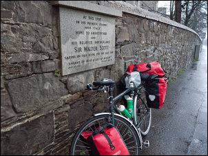
Sir Walter Scott plaque and bike |
|
I took a minor road down to Melrose
Abbey but the rain continued so I couldn’t get a photo. The entrance
fee was high and most of the ruin was covered in scaffolding. I
followed a muddy track to Chain Bridge Farm then as the name
suggests came to a chain foot bridge over the river Tweed. At
Gattonside I turned right on to the B6360 but soon saw a diversion
sign and suspiciously no traffic. |

Chain Bridge |
|
I rode on for a couple of miles
wondering if the road was closed and I couldn’t get through.
Approaching the A68 trunk road the answer was ahead. The road was
closed for the day while they resurfaced it. Fortunately it was easy
for me to ride bye. I joined the busy A68 and headed north, wanting
to get off it as soon as possible. A couple of miles later I reached
Earlston and was able to turn right on to the A6105 which was
thankfully quiet. For several miles there was little to see, until
the final approach to Gordon. Standing on a small hill to my left
was the impressive Greenknowe Tower. It was built in 1581 for James
Setton and his wife Janet Edmonstone. It subsequently passed to
other owners and was abandoned as a residence in 1850. The Dalrymple
family gave it to the state in 1937. |
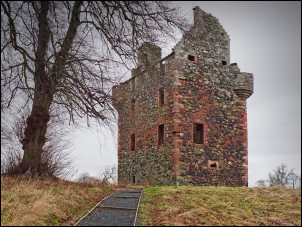
Greenknowe Tower |
|

Greenknowe Tower entrance |

Greenknowe Tower interior |
|
I returned to |
|
|
I pressed on along the A6105 for
several more miles to Greenlaw. The constant rain reduced the
visibility making it a fairly dreary ride. I left the town by a long
climb up on the A6112. Eventually I reached Duns and seeing a car
park and toilet sign decided to investigate. I didn’t find the
toilets but saw a supermarket where I called in for something to
eat. When I emerged a young lady was leaving with her shopping and
seeing my bike asked about my journey. We chatted for a while then I
had to leave as time was getting on. I continued north to Preston
(not the Lancashire one) and on the way crossed the bridge over
Whiteadder Water. |

Whiteadder Water bridge |
|
A sharp left and I was on the minor
B6355 which climbeds steadily up the valley. It was a pleasant ride
considering the bad weather. At Cranshaws I turned right up an
unmarked road towards Harehead. It looks just like a farm track but
the map shows it as a public highway. The climb was steady at first
then got steeper on the final pull up to Peat Law summit. I could
see a monument on the hill to the right but couldn’t see a path to
it. It had now stopped raining but was getting very near to sunset.
Earlier in the day I’d heard the disconcerting grating sound of my
back brakes as the blocks had worn through so I now only had the
front brakes working. Over the summit I had a long steep descent
through forest and I had to be on the watch out for ice as the
temperature had now dropped considerably. |
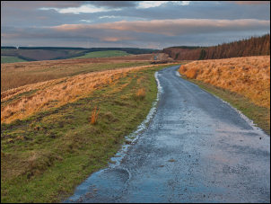
Near Peat law summit |
|
As I reached a minor summit I suddenly
saw the large illuminated outline of Torness Power Station in the
distance. When I’d reached the houses at Innerwick it was dark. A
couple of miles later I descended to Skateraw Harbour where I’d
camped on a previous occasion. My first call was to the public
toilets by the car park where last time I’d got water from the wash
basin. It was locked! There is an isolated bungalow on the short
stretch of coast road so I called there. A light was on so I knocked
on the back door and a lady emerged to turn on the garden hose to
fill my two bottles. I returned to the bike and rode back to the
toilet block to camp behind it. Last time I was out on the point but
now the grass to too long and wet. Through the dark I had a good
view of Torness Power Station that was commissioned in 1988 |

Wind turbines on the descent |
|
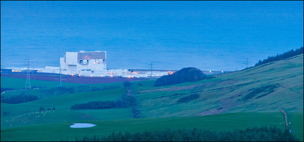
Torness Power Station |
|
|