|
I’ve two reasons for escaping to the
hills today. The first is a plan I’ve had for a long time to camp on
the summit of Cross Fell. The second is more recent and that I am so
sick of the media coverage of the run up Fridays wedding of Kate and
Wills I want to escape to the hills until it’s all over, or until
it’s safe to come down. My first planned pitch was to be above High
Cup Nick so I wanted to leave my car in Kirkland. To save carrying
my full pack at the start of the walk I firstly drove to Knock and
left by pack in the bus stop shelter by the public phone box before
driving on to Kirkland. There is a small car park at the end of the
road and as there didn’t seem to be a ban on overnight parking I
thought it would be OK to leave the car. I walked back down the road
and left up the lane to the farm at Baron’s Hill. The map shows an
area called ‘Hanging Walls of Mark Anthony’ the map also reveals
that they are ancient cultivation terraces. |
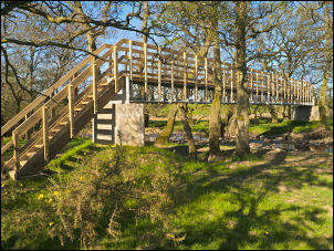
substantial new footbridge |
|
They looked
quite interesting but how anyone could describe them as hanging
walls I can’t imagine. It was a pleasant sunny day with little wind
as I continued to the end of the track and the property of Wythwaite.
Across a large open field I came to a fairly small river and a large
and substantial new footbridge. It looked over large and over
designed for the river it crossed. Considering the thousands it must
have cost it seemed odd that over the river there was no way marker
to show which direction to go. The path is so indistinct that there
is no sign of it as it crosses High Slack. At the far side I picked
up a way marker and then a series of stiles showed the way clearly
through fields and walled tracks to Milburn. Emerging in to the
village from the open fields is a delight. An open expanse of
manicured grass is surrounded with stone houses and occasional apple
blossom trees in full bloom. Walking down the centre I stopped
briefly by the flagless flagpole. It is huge and I wondered if it
has other significance. I turned left at the telephone box to look
for the footpath. I asked a young lady and two children who
confirmed I was on the right track. Crossing a long field I crossed
Stank Beck by a footbridge. The map shows the path on the right side
of the wall but there was no sign. I was now walking on recently
planted crops. After passing a large new wind turbine I came to
large new farm outbuildings. There was no sign of the path so I had
to ask a farm worker. He said the proper route for the path was the
opposite side of the wall. Why can’t they put a simple sign up? I
left Low Howgill and reached High Slakes then across fields to
Milburn Grange. |
|

Sheep near Milburn |
It was then back across fields to
Close House, across more fields to emerge on the road through Knock.
It had been a very enjoyable walk without my pack and remarkably
easy. I returned to the bus shelter and retrieved by ruck sack.
Before heading up into the hills I decided to sit on a bench in the
village and eat some sandwiches I’d left with my pack. A lady from
the house opposite saw me and brought me a glass of water, which I
gratefully accepted. We chatted for a while about my walk and her
husband emerged and joined in. They were retired and moved to Knock
30 years ago. I thanked them and continued along the street. I
turned left up a track then a footpath across fields to the base of
Dufton Pike at the Pennine Way. |
|
I’m still mystified by the number of
paths with the Pennine Way label. Are there many routes or does it
go in circles. A farmer was herding sheep through the gate with his
quad bike and dog so I sat quietly so as not to disturb the sheep
and allow them through and the gate to be shut. I then continued on
my way along the path above Great Rundale Beck. Through a gate a
landrover was parked and below two men were re-building the dry
stone wall. |

Doorbell in Milburn |
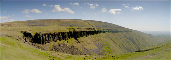
wide view on the approach to High Cup Nick |
|
The path I was on
was now track status and followed a spectacular line along the steep
north side of Dufton Pike. I came to the main track and followed it
to the left then soon left it to follow a minor track heading
steeply up and over Bluethwaite Hill. Through a gate it continued up
Cow Band but then I left it to cross Little Rundale Beck, which was
dry, and head off across open fell. Even up here were old spoil
heaps and shafts. It was a bit difficult underfoot so I was glad to
eventually reach the main path, another version of the Pennine Way,
towards High Cup Nick. I soon got a good view of the vast bowl shape
of the Nick. The path was rough for a while but then improved to a
wide green track which was nice to walk on. There was hardly any
water coming down the beck so only a dribble was dropping down to
the valley below. |
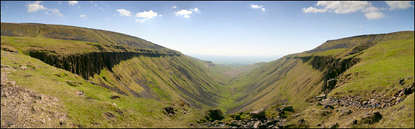
wide view from the Nick |
|
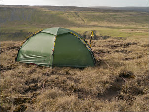
Camp 1 above High Cup Nick |
As I rounded the head of the Nick I
looked up ahead to my planned camp. The gulley where I’d hoped to
get water was dry as I climbed up the side. At the top there a small
a trickle which was just enough to scoop up in my pan. A little
higher I pitched my tent for the night. |
|
|