|
There was a strong westerly wind
blowing as I drove along the motorway. I reached Croglin and
thankfully the rain held off. I left my car in the village near the
Church and set off along the track by Town Head Farm. As I
approached the top of the track near Plantation Nook there was a
land rover I’d seen earlier and the occupant was talking to another
man with a quad bike nearby. The only reason I mention this is that
the quad bike had a special bracket on the front and a shotgun
sitting in a cradle. A large newish building was also nearby which
seems to serve no other purpose than a large sort of canteen. It’s
probably connected with the grouse shooting set up in the area. |

on the track from Croglin with King Harry's Plantation
in the distance |
|
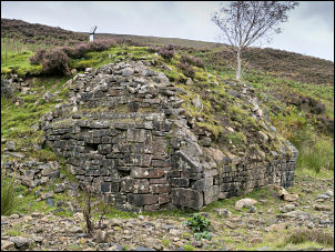
all that's left of the bridge abutment |
I turned right then immediately left
to continue north along a wet stony track. Through a gate the track
improved. To the east I could see the remains of old and extensive
quarry workings. To the west and SW were views across to the main
Cumbrian fells. The track is walled both sides and undulates for
about a mile before descending steeply towards Newbiggin and the
river. Just before the river I turned right to follow the footpath a
short way before crossing the shallow river to join the main track
up the opposite side of the beck. The track was mostly good
underfoot and I enjoyed the route over the summit and then the
steady descent by Eller Beck and New Water. I could see the
continuing track on the far side of the river. I’d seen the track
from the other side on an earlier walk some months ago. The map
shows the track continuing over the river but when I got there the
reality was much different. The track came to an abrupt end high
above the river. |
|
I was standing on the top of a very
large masonry structure which would have been the abutment of one
side of a substantial stone bridge. The other side of the bridge had
long since been washed away. The river was far too deep and wide to
hop across stones so I had to take my boots off and wade across.
Thankfully the air temperature was just above 10degC and the water
temperature was bearable. The far bank was a steep climb to regain
the original line of the track. Looking back at the remains of the
bridge it has been collapsed for many years and so maps should have
been updated or at least a notice placed at the start of the track.
As I continued north I noticed how well it had been made and had
been constructed with a stony wearing course indicating that it used
to be of considerable importance at on time. |
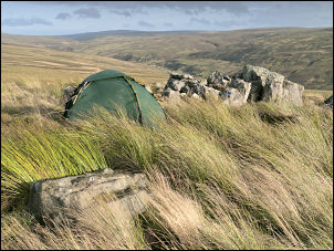
my tent by Lord's Seat rocks |
|
On the approach to
Old Water I turned sharp right to follow a very faint track up
Middle Top towards Lord’s Seat rocks. The track is shown clearly on
the map but has almost vanished on the ground. I followed it
steadily upwards and over the summit of Middle Top. There was no
marker cairn that I could see but the Lord’s Seat rocks were plainly
visible and quite interesting. This was my planned camp for the
night but finding water was going to be my next problem. The map
shows a drainage ditch but as I followed it there was nothing more
than a succession of small stagnant ponds along its length. I’d
almost descended 1/2 mile to new water before I found a small
running stream of very dark brown water. When I’d done the long
climb back up the rain started. It was also very windy as I put the
tent up. I was intrigued by the rocky outcrops as many rocks had
been placed in various cracks and gaps to form a more efficient wind
break. One east facing rock had the clean, tidy and fairly new
looking inscription ‘William Wilson 1919 -2009’
Later in the afternoon the rain increased to torrential but didn’t
last long. I was so glad I was inside the tent. |
|
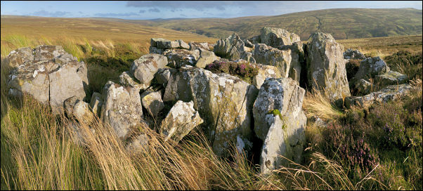
Lord's Seat rocks on Middle Top |
|
|
|
|